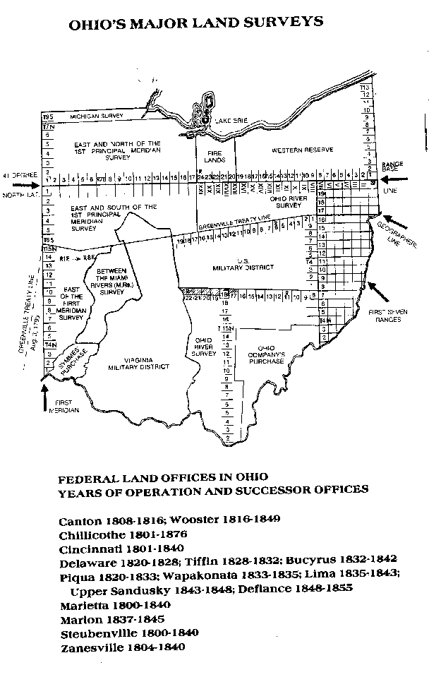
Before June 1, 1792, Kentucky was part of Virginia. A Resolution passed by the Virginia General Assembly dated December 19, 1778, proposed the location of the Military District as follows:
"That it is the opinion of this committee, that a certain tract of country to be bounded by the Green river and a southeast course from the head thereof to the Cumberland mountains, with the said mountains to the Carolina line, with the Carolina line to the Cherokee or Tennessee river, with the said river to the Ohio river, and with the Ohio river to the said Green river, ought to be reserved for supplying the officers and soldiers in the VIrginia line with the respective proportions of land which have been or may be assigned to them by the general assembly, saving and reserving the land granted to Richard Henderson and company, and their legal rights to such persons as have heretofore actually located lands and settled thereon within the grounds aforesaid."
The Virginia Land Law of May 3, 1779, confirmed the location proposed in the resolution.
After separating from Virginia, the Kentucky General Assembly opened the military district to settlers meeting age and residency requirements. Although the Act of December 21, 1795, was amended several times, the premise was the same - military claims needed to be filed or they would be void. The 1795 law stated lands not claimed by the veteran, his heirs or assigns before January 1796 faced forfeiture to settlers filing under the South of Green River Series of patents.
In 1818, lands west of the Tennessee River were purchased from the Chickasaw Indians. A number of Revolutionary War veterans had settled on the lands prior to the sale. On December 20, 1820, the Kentucky General Assembly approved an Act for surveying the military claims west of the Tennessee River. It reads in part:
"Be it enacted by the General Assembly .... That the surveyor of the lands set apart for the satisfaction of the legal bounties of the officers and soldiers of the Virginia line or state embellishment be, and he is hereby authorized and required by himself or his deputies, to secure chain carriers and markers, and to survey without delay, all entries made in this office, prior to the first day of May, 1792, on warrants for military services aforesaid; and shall make out a full and fair connection of the surveys so made, showing where & how they interfere with the townships and sections of the land as laid off by William T. Henderson .... That the surveys made in pursuance of this act, shall contain the quantity of land specified in such entry, and no more .... If the person or persons entitled to any plat & certificate of survey directed to be made by this act, shall not take the same out of the surveyor's office, and cause the same to be filed with the register of the land office, on or before the first day of January, 1823, the right of such person ... shall be considered lapsed and forfeited to the state."
Records filed with the Secretary of State's Land Office indicate 242 patents were issued to Revolutionary War veterans, heirs or assigns in the West of Tennessee River area (the Jackson Purchase).
Ohio Military District
Not all Virginia veterans, heirs or assigns had used their military warrants, either in whole or in part, in the South of Green River Military District before Kentucky's statehood in 1792. Virginia had reserved land in Ohio as part of a cessation compromise with Congress, and a portion of that area was deemed Virginia's second military district.
Warrants used in the Kentucky Military District end with #4627. If research indicates a veteran received a higher number, it was most likley used in Ohio. If the "Authorized" field in the Revolutionary War Warrants Database is blank, we suggest you contact the Ohio Historical Society, 1982 Velma Ave., Columbus, OH 43211 to research warrant usage.
The Ohio Military District lands are found in 23 counties from the Ohio River northward, between the Scioto and Little Miami Rivers, as far as 141 miles inland.

By Acts of Congress dated May 30, 1930, and August 31, 1852, Virginia military warrants could be exchanged for land scrip. Land scrip could be used to acquire any public lands open for entry at private sale, according to research on the Western Reserve. For further information, please visit the Ohio Land Patents Database.
Further Research
For more information about states and military districts, this office recommends Lloyd DeWitt Bockstruck, Revolutionary War Bounty Land Grants Awarded by State Governments (Genealogical Publishing Co.), ISBN 0-8063-1511-3.