The Jackson Purchase is the only Kentucky area mapped by townships, ranges and sections:
- A principal meridian was established bisecting the Jackson Purchase, dividing the region into West and East.
- Acreage in the Jackson Purchase was divided into square blocks called townships. Each township contained 36 square miles.
- The townships were then divided into 36 sections of 640 acres (1 square mile) each.
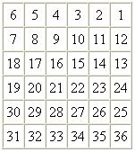
- Each 640-acre section was then divided into quarter sections of 160 acres each.

- Starting at the juncture of the principal meridian and the base of the Jackson Purchase and running East and West, the blocks were assigned range locations.
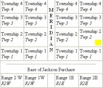
The location of the yellow box would be identified as: NE, SE, NW and SW Qr Sections of Sec 36 T-2 R2 E or Section 36 of Township 2, Range 2 East. The total acreage for this patent is 36 acres.
The "West of Tennessee River" chapter of Jillson's Kentucky Land Grants lists names of grant recipients and tract locations for West of Tennessee River Non-Military Patents. The Jackson Purchase Locator allows you to determine patent locations online.
Patent documents, including the receipt declaring the buyer, purchase price, names and signatures of other assignees, and the governor's grant finalizing the patent are available on the West of Tennessee River Non-Military Database.